Parkways, Avenues, Places, and Circles
The unique feature of the original Olmsted park system plan for Buffalo was the extension of the park experience well beyond the confines of the acreage set aside for park grounds through a system of connecting parkways. The so-called Park Approaches of the original system consisted of four “parkways”, which were 200 feet in width and totaled 3 miles in length, and three “avenues”, which were 100 feet wide and totaled 4 miles in length. Combined, the park approaches added about 125 acres of parkland to the city. The parkways (Chapin, Bidwell, Lincoln and Humboldt) were each designed with two separated drives, wide greensward spaces, pathways, and several rows of trees. The trees were specifically chosen so as to provide uniformity of species and age, and were planted equidistantly along each row. The longest of the four, Humboldt Parkway, extended for over 1-3/4 miles, linking “The Park” (now Delaware Park) and “The Parade” (now Dr. Martin Luther King, Jr. Park) via a magnificent swath of greenspace. The “avenues” (Richmond Avenue, originally called simply “The Avenue”, Porter Avenue and Fillmore Avenue, originally called the “East Side Boulevard”) each had a single drive and no central planting space, but were lined by uniformly planted trees on each side of the roadway, which was set well off from the adjacent residential lot lines.
The Buffalo park approaches were significant in that they were constructed, maintained and controlled by the Buffalo Board of Park Commissioners, not the regular city authorities. The Board prohibited commercial traffic, and was also able to exert significant control over where normal city streets could access the major parkways. Commercial businesses were also restricted from being established along the approaches, with the Board also able to regulate signs and similar non-residential aspects of these special parts of the Buffalo park system. Delaware avenue, it should be noted, was not an Olmsted design and has never been part of the city’s park and parkway system. Despite the prominent residences which once lined this thoroughfare, it has always carried commercial traffic and was not subject to Park Commission regulation. (The park approaches of the later extension of the park system south of the Buffalo River are separately addressed elsewhere in this website.)
The Places and Circles
On the park approaches, several important street junctions were specially laid out and landscaped under the Park Board’s control, with Olmsted specifying their designs. The “places” were all rectangular in shape, while the “circles” were as their name describes.
Soldier’s Place, which was subsequently (and confusingly) renamed as Soldiers Circle when its roadways were altered and center island reduced, is at the terminus of Chapin and Bidwell Parkways, with Bird avenue crossing it; is then the origin point of Lincoln Parkway, which in turn terminates in Delaware Park (originally, at “The Drive”, the park’s principle carriageway). It was the largest of the places and circles, fully 700′ across. It was intended specifically as a space to contain a monument to honor the veterans of the recent Civil War, thus the name; the monument envisioned for emplacement there however did not come to fruition and was later erected at Layfayette Square downtown.
Bidwell Place, 510′ x 465′ in size, is now called Colonial Circle, with a revised roundabout traffic pattern, changed at the same time as Soldiers Circle was altered. It is located at the intersection of Lafayette avenue (once Rogers street) and Richmond avenue (originally “The Avenue”). It is the origin point of Bidwell Parkway.
Chapin Place, 500’x 420′ in size, is now known as Gates Circle and is located at the intersection of Delaware avenue (once Delaware street) and Ferry street. It is the origin point of Chapin Parkway. Chapin Place and Chapin Parkway were named for Col. Edward Payson Chapin (August 16, 1831 – May 27, 1863), a Buffalo attorney and Civil War officer killed at the Battle of Port Hudson, Louisiana; he was posthumously promoted Brigadier General.
Gates Circle, as it is known today, is not as it was when designed by Olmsted. It was re-named in 1902 when its central portion was redesigned by Buffalo architects Green and Wicks in the Beau Arts style to accommodate an elaborate granite fountain with seating in its center. It was renamed in honor of Mr. and Mrs. George B. Gates, the parents of Mrs. Charles W. Pardee who donated fountain an its accessories to the city.
Symphony Circle, (originally simply called “The Circle” until 1957), is 500′ in diameter and is located at the junction of Wadsworth, North and Pennsylvania (once 14th street) with park approaches Porter avenue and Richmond avenue (originally called “The Avenue”. About 1938, its central light fixture was been removed as was the central island, the central island was restored and a replica of its light fixture (matching that at Ferry Circle) in 2002.

Agassiz Circle, now greatly modified by the expressway projects of the 1950s and 1960s, is 490′ in diameter and is at the junction of Humboldt Parkway, the former carriage concourse of Delaware Park, and Parkside avenue. It was named for Jean Louis Rodolphe Agassiz (28 May 28 1807 – 14 December 1873) a Swiss-American scholar of natural history. The circle’s center island has been destroyed by the expressways crossing it.
The two smallest of the original Olmsted circles were 300′ in diameter:
Ferry Circle is at the junction where West Ferry street and Richmond Avenue intersect. Its center island had been removed in the late 1930s, but it was restored in 2002 and a replica of its 5-lamp ornamental light fixture matching that at Symphony Circle was installed.
“The Bank”, no longer existing, was at the junction of Sixth street (later, Front avenue, and now Busti avenue), Massachusetts street, and Niagara street. Later, a connecting park drive, Sheridan Terrace, also entered The Bank, linking it to The Front via a strip of Federal land on the periphery of the Fort Porter grounds. Construction of the Peace Bridge in 1927 brought about the loss of this circle. Only a tiny slice of its eastern perimeter remains.

All of the places and circles were designed with a double row of trees on their outer perimeters, and they had center planting spaces which added green space to the vista down the roadways entering them, breaking the appearance of unending pavement as one traveled the thoroughfare. They also provided setbacks for the houses built along their periphery, with perimeter walkways nestled amidst the trees.
The Avenues and Parkways
The park approaches served both as a means for a visitor to travel from one point in the parks to another without ever leaving the park setting, as well as an extension of the park system to a large portion of the city, in that a resident who might have had to travel a considerable distance to visit one of the three major park grounds could rather easily walk to one of the parkways to partake of a portion of the experience or reach them by a streetcar ride. By May of 1874, 1060 elms had already been planted on the west side approaches, with more to come.
The Avenues
The Avenues were 100 feet wide extensions of parkland which, like their broader Parkway counterparts, were corridors between and entrances to the parks.
“The Avenue”, now Richmond avenue, has a single central roadway, and was originally planted with two rows of American Elms on either side of the roadway.
Porter Avenue was originally known as York street. As a park approach, it was widened from a standard 66 foot wide city street when control passed to the Park Board, and it was renamed. When first created, Porter avenue ran from Front Park (“The Front”) at Sixth street (later, Front avenue, and now Busti avenue), past the Prospect Parks, to Symphony Circle. From that circle it continued as Richmond avenue on up to Delaware Park. It had the same planting arrangement as Richmond avenue. In 1893, additional park lands were acquired between The Front and Lake Erie, on the far side of the Erie Canal and a railroad right of way with the intention of creating additions to The Front. The Board decided to expand the portion of Porter avenue to and over the canal from a standard 66 foot city street to the same 100 foot width as the main portion and include it as a park approach. The then-existing bridge bridge over the canal was to be removed, and a new span, faced with decorative wrought iron and as wide as the revised thoroughfare, was constructed. Later lost to New York State Thruway construction, its decorative stone abutments remain.

Fillmore Avenue
Similarly, a connection between The Parade to the southern part of the city was sought. As that section of the city was already developed with an existing street network and many dwellings, finding a satisfactory route was more difficult than on the west side of the city. Added to the challenge was the difficulty of crossing several railroad rights-of-way and the need to maintain a reasonable construction budget. The Board of Park Commissioners determined that portion of Fillmore avenue, with ran up past Seneca street and terminated at Best street and The Parade was the best option for the route. Fillmore Avenue then was designated as a park approach as far south as Seneca street. Work was undertaken to bring it to a similar appearance as Porter and Richmond avenues which were simultaneously being constructed. It was completed and landscaped as far south as William street, but the rail lines crossed the planned route beyond that street. The difficulty of passing the railroads beyond was not resolved. That problem, coupled with an ever increasing press of commercial traffic and interests finally caused the Board to abandon the designation and return Fillmore avenue to city jurisdiction.
The Parkways
The Parkways were 200 foot wide extensions of parkland into the city proper, serving as entrance corridors to the parks. They all had a wide central median planted with xx rows of trees, two traffic lanes, each 60 feet in width, and planted margins with side walkways.
Bidwell Parkway runs from Richmond avenue (or, as it was originally known, “The Avenue” and Lafayette avenue (formerly Rogers street) to Soldiers Circle (or, “Place”). It originally had four rows of American elm trees in its central median, a pair of roadways, and another line of trees between the roadways and its walks. It provides a continuing park atmosphere for travelers between Delaware and Front parks. (The section of present Richmond avenue beyond Lafayette avenue was not a designated park approach; rather, it was a normal city thoroughfare.) Bidwell Parkway today is still close to its original design.
Chapin Parkway runs from Gates Circle, originally Chapin Place, at the junction of Delaware avenue (once “street”) and Lafayette avenue to Soldiers Circle (once, “Place”). It originally had three rows of elm trees in its central median, a pair of roadways, and another line of trees between the roadways and its walks. It was intended to provide a sylvan passage to the park from Delaware avenue, which was then Buffalo’s prime residential street. Delaware avenue was not afforded a direct access to the park until much later; it originally passed through the park and was screened from it. Connecting to a similar path in Lincoln Parkway, a bridle path, long gone, was opened in Chapin Parkway in 1893. Chapin Parkway is still much as it was originally built.
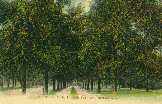
Lincoln Parkway is the grand entry into Delaware Park from the direction of downtown Buffalo and is the culmination of the park approaches coming from Front Park. It is 200 feet in width. It has a wide central roadway, originally 50 feet wide, flanked by two side roadways of 25 feet in width intended for the use of adjacent homeowners. It was originally planted with 6 rows of American Elms, 1 on each side of the main carriageway and two more rows outside of each of the side roads. Permission was granted in 1893 for use of the turf alongside the main drive as a bridle path. During the Pan American Exhibition in 1901, the Lincoln Parkway entrance to the park also served as the main entrance gate to the exhibition. It remains basically intact today.
Humboldt Parkway was the longest of the Buffalo park approaches. Of all the parkways and avenues Frederick Law Olmsted designed for Buffalo, Humboldt Parkway was the most magnificent. It was almost two miles in length and two hundred feet wide, with two roadways, a sixty foot median and with trees lining the sides of the roadways. It was first planted with young tulip trees, but when those proved unsuitable for the soil conditions, one thousand young maple trees replaced them. Construction of this parkway began simultaneously with work on the parks proper and on the other original park approaches. When the first of its roadways was opened to traffic in 1874 it marked a first for Frederick Law Olmsted, for never before had two of his designs been actually been connected by a parkway extending between them.
Changes
Just as the City Beautiful movement brought monuments and large structures to Delaware Park, so too it affected the park approaches. As mentioned, Chapin Place, as designed by Olmsted, was lost when it was completely redone as Gates Circle in the Beaux Arts fashion. Olmsted’s layout was supplanted by a large fountain and pool with granite walls and seating. Bidwell Place and Bidwell Parkway had both been named for Brigadier General Daniel Davidson Bidwell (August 12, 1819 – October 19, 1864), who was mortally wounded at the Battle of Cedar Creek, Virginia. He was the senior local Army officer to be killed in the Civil War. Bidwell Place later was renamed as Colonial Circle. An equestrian statue of General Bidwell by sculptor Sahl Swarz was installed in Colonial Circle in 1924, an installation unanticipated by the original design. Soldiers Place underwent a name change, to the current designation Soldiers Circle, reflecting that several years after it was first opened its roadway was redesigned and its central planting area reduced while the outer planting areas were considerably enlarged. It was felt that traffic was having difficulty transiting the space under Olmsted’s original plans. In 1897, Soldiers Circle also received a display of four large naval parrot rifles mounted on carriages and flanked by stacked cannon balls. Colonial Circle also had similar guns and projectile displays. (The cannon and projectiles were removed from Colonial Circle in 1936 and from Soldiers Circle in 1937.)
After 1916, when the functions of the park board were assumed by the city directly, many of the protections afforded the parkways were reduced or were more easily circumvented. Greater access to automobile traffic was granted as the use of automobiles increased. Declared a threat to motorists, the cannons and ammunition stacks were removed from Colonial Circle and Soldiers Circle in 1936 and 1937, respectively, and relocated to Front Park. Eventually, the center islands of Ferry Street and Agassiz Circles were removed and that of Symphony Circle reduced in size to help facilitate vehicular traffic flow. As noted previously, “The Bank” was lost to the construction of the Peace Bridge.
Destruction of the Parkways
After World War 2, major changes were made to the street and roadway network of Buffalo and the surrounding area, changes which were echoed throughout New York State. The new changes made the alterations outlined above seem inconsequential. Indeed, these traffic projects were to wreak havoc on the Olmsted parks after the Second World War. A 1946 traffic master plan was the genesis. That year, the population of the city was over 575,000 persons; the first ring of suburb populations had about half the number of residents they have now, with agriculture still quite viable in them. The outer ring suburbs were all lightly populated rural farmland. It proposed the routes of the then incomplete New York State Thruway Mainline and Niagara extension should follow the paths eventually built. Eleven arterial expressways would be built to speed traffic into, out of, and around Buffalo. High rise bridges on NY Rte 5 would span the Union Ship Canal in Lackawanna (the original Father Baker bridge), and the Buffalo River (the Skyway). At that time, Humboldt Parkway was still in pristine condition, but the volume of traffic it was handling was much greater than intended.
Humboldt parkway was affected by three of those original 11 expressway plans. First, it was proposed that the section of Humboldt Parkway from Monticello and Eastwood Places east to Crescent Avenue be excavated so as to pass 14 feet below grade under Main Street and Kensington Avenue, with four lanes of traffic traveling on a 60 foot wide highway with a median divider. This would connect at Agassiz Circle with a new 6 lane expressway along the border of (read that as “through”) Delaware Park, replacing the park carriage concourse. Second, a new expressway would cut through Buffalo’s Fruit Belt neighborhood from Michigan avenue, running parallel to Cherry street, thence at North street paralleling Herman street to Best street, and finally connecting with Humboldt Parkway. Third, another new expressway would connect Kensington avenue to Humboldt parkway, with Kensington avenue widened to 60 feet, and terminating at Bailey avenue. In the latter two plans, no physical alterations to Humboldt Parkway other than the underpass project at Main street were proposed.
There was heavy pressure placed on the city to adopt the plan by the state Department of Public Works. The cost of the project, which would take 7 years to complete, would be $69,000,000 ($1.1 billion in 2026 dollars.) The carrot dangled was that the city would only have to pay about 7.5 percent of that amount. The state urged early acceptance, and claimed it was ready to proceed with portions of the work almost immediately.
Strong opposition to the destructive impact on Humboldt Parkway by the underpass project surfaced almost immediately. Construction of the underpass eventually won out, commencing in October of 1950, and the bypass was opened to traffic in October of 1952.
Before that first element was finished, the next shoe dropped: the expressway through Agassiz Circle, along the Delaware Park meadow (including the portion of the park drive, to meet with a new cloverleaf ramp at recently widened and straightened Delaware avenue began construction in 1952. That Delaware avenue project, which had commenced in 1950, caused the destruction of the Vaux-designed stone arch bridge over Delaware avenue, and replaced it with a modern stone-faced double arch span. While this project only directly affected Delaware Park and Agassiz Circle, it set the stage for future expressway intentions for on Humboldt Parkway.
Then came the 3.2 mile long Scajaquada Expressway, NY Route 198, which began construction in the mid 1950s, and was opened to traffic on 8 Dec 1959. The 4 lane, limited access, divided highway presently connects the Niagara Section of the New York State Thruway, Interstate Highway 190 with NY Route 33 (which, in turn, provides access to the mainline New York State Thruway, Interstate Highway 90 or to downtown Buffalo.) It travels along the southern bank of Scajaquada Creek, and for some distance over it, and it replaced the carriage drive of Delaware Park with a four lane limited access expressway, dividing the magnificent Delaware Park into two sections. It then continues below grade along the western segment of Humboldt Parkway. It was intended to provide a crosstown connection from the Thruway to the Kensington Expressway and thence to downtown or to the main section of the New York State Thruway and to the Buffalo Airport.
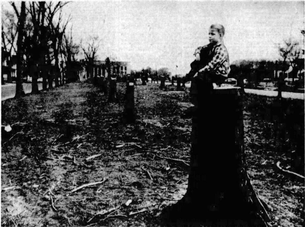
Connecting to the Scajaquada Expressway is what came to be known as the Kensington Expressway (NY Route 33) It begins downtown at the eastern end of the Elm-Oak Expressway, travels as a below grade, six lane, arterial highway where the Humboldt Parkway once stood, then branches, with the main route swings east leading to the Buffalo Airport in Cheektowaga and the other portion connecting to NY Route 198 through the park. After considerable discussion, construction began, in three phases. Noteworthy is that the destruction of the Humboldt Parkway’s green space was missing from the debates. Early on, in 1960, all of the hundreds of maple trees on Humboldt Parkway were felled. The portion running from Michigan avenue parallel to Cherry street destroyed dozens of homes an businesses across Buffalo’s Fruit Belt neighborhood. When the section from Jefferson avenue to Harlem Road opened in 1967 the entirety of Humboldt Parkway was completely destroyed. Moreover, it divided and ruined the beauty of vibrant neighborhood which had been formed along its course, replacing it with toxic fumes, ugly concrete and unabated traffic noise.
Nor were the state and city done building highways over parkland. In 1989 and 1990, first the inbound and then the outbound Kensington Expressway had a third lane added, creating a 6-lane thoroughfare.
These 1960’s era expressways obliterated the park’s main carriage drive, the Scajaquada Parkway, and Humboldt Parkway; they introduced major new highway access roadways into parkland; and they and split Delaware Park into two entities. In addition, the huge amounts of rock and soil created by the excavations of these roads were dumped into the park lake, causing major modifications to its outline and the elimination of most of its North Bay, and wreaking terrible damage to the Olmsted design. For what? To cut only 3 to 5 minutes from someone’s work commute.
The Present
The resurgence in interest in Buffalo’s Olmsted parks which blossomed in the 1980s and 1990s has had a positive impact on the Olmsted park approaches. Street lighting was changed, beginning with the original parkways, to special ornamental fixtures. The missing center islands of both Symphony Circle and Ferry Circle were restored in 2002. The work included replacement of the center islands and replication of the central light standards. The speed limit on the Scajaquada Expressway, following a tragic accident when a vehicle veered into the park and resulted in a fatality of a young park visitor, was reduced to 35 miles per hour east of Grant street, and other traffic calming alterations to the roadway were installed. Still in limbo is a proposed action to rebuild the roadway and restore it to full parkway status. Agassiz Circle has not benefited, however, and any improvement to its condition is going to be dependent on completing the restoration of NY Route 198 as a parkway. New York State Department of Transportation, in conjunction with an impending reconstruction of the Kensington Expressway, proposed decking over a portion of the highway in a partial restoration of the old Humboldt Parkway. It would retain the highway at six lanes, but cover the depressed section, creating a 4,150 foot long pair of tunnels between Sidney Street and Dodge Street. The proposal had a major flaw: it claimed that there would be no significant environmental impact. A lawsuit brought by the project’s neighbors successfully challenged that assertion, and the project is on hold with the neighboring community demanding a full surface restoration of the parkway as near to its “as built” status as possible.
Traffic projects were to wreak havoc on the Olmsted parks after the Second World War. A 1946 traffic master plan was the genesis. It proposed several arterial expressways to speed traffic into, out of and around Buffalo. For a time, the plan was only a proposal. But, in the 1950s, that plan was ‘dusted off’, updated, and then acted upon. The first impact was on the section of Humboldt Parkway from Monticello and Eastwood Places east to Crescent Avenue; that portion of the parkway was excavated to pass as a 60′ wide highway under Main Street and Kensington Avenue. The plan was finalized in late 1950, but strong opposition to the destructive impact on Humboldt Parkway blocked the project for over a year. Construction eventually won out, and the bypass was opened to traffic in October of 1952. Then, the 3.2 mile long Scajaquada Expressway (NY Route 198) began construction late in the 1950s, and was opened to traffic on 8 Dec 1959. It runs as a 4 lane limited access divided highway from the Niagara Section of the New York State Thruway (Interstate Highway 190) along over the southern bank of Scajaquada Creek, and for some distance over it as a significant portion of the creek new feeds into a tunnel. It replaced the carriage drive of Delaware Park, serving as barrier dividing the magnificent Delaware Park into two sections. It then continues below grade along the western segment of Humboldt Parkway. It was intended to provide a crosstown connection from the Thruway to the Kensington Expressway and thence to downtown or to the main section of the New York State Thruway and to the Buffalo Airport.
Connecting to the Scajaquada Expressway is what came to be known as the Kensington Expressway (NY Route 33) begins downtown and leads to the Buffalo Airport in Cheektowaga, mostly as a below grade, six lane, arterial highway. After considerable discussion, construction began, in three phases. Noteworthy is that the destruction of the Humboldt Parkway greenway was missing from the debates. Early on, in 1960, all of the trees of Humboldt Parkway were felled. When the section from Jefferson Avenue to Harlem Road opened in 1967 the entirety of Humboldt Parkway was completely destroyed. The Humboldt Parkway trees were cut down and the parkway paved over. Moreover, it divided and ultimately destroyed the beautiful vibrant neighborhood which had been formed along its course.
These expressways obliterated the park’s carriage drive and Humboldt Parkway, introduced major new highway access roadways into parkland, and split Delaware Park into two entities. In addition, the huge amounts of rock and soil created by the excavations of the below-grade expressways was dumped into what is now Hoyt Lake, destroying most of its North Bay as well removing much of the lake’s Olmsted-intended character.
The resurgence in interest in Buffalo’s Olmsted parks in the 1980s and 1990s had a positive impact on the Olmsted park approaches. Street lighting was changed, beginning with the original parkways, to special ornamental fixtures. The missing center islands of both Symphony Circle and Ferry Circle were restored in 2002. The work included replacement of the center islands and replication of the central light standards. Agassiz Circle did not benefit, however, and any improvement to its condition is dependent upon a restoration of Humboldt Parkway and on completing a restoration of NY Route 198 to parkway status.
250331